
Looking at landscapes anew...

I spent a pleasant few hours earlier today in the valley of the Gaywood River, just east of King's Lynn with colleagues from UEA and the Norfolk Wildlife Trust. We were involved in testing out an augmented reality solution for allowing visitors to a place to find out more about the nature's benefits / ecosystem services in that area.


Sarah Taigel has created, and is trialling an application called VesAR which stands for Visualising Ecosystem Services using Augmented Reality. It uses an app called LAYAR, which I have previously experimented with. 


Holding the phone or tablet up at particular locations reveals 'hotspots' floating in the camera view, which contain more information about what the visitor is looking at. (See the image below)
Ecosystem services are split into three types:

Regulating

Provisioning

Cultural

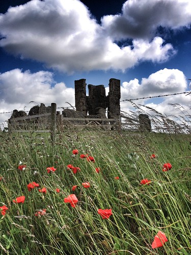
Essentially, a landscape like the river catchment we walked through provides three types of benefits, e.g. a regulating benefit would be the grazing meadows along the river, which slow down runoff after rainfall and reduce the flood risk, a provisioning benefit would be the nearby Reffley Woods, which provide a source of timber, and a cultural benefit would be the ruin of St. James church (pictured above) which provides a historic reminder of the way in which the landscape was used in the past.

You can perhaps think of other examples of the three types of benefit. 
Landscapes are increasingly being managed to protect the existing benefits, and to provide more benefits where possible.


You can read more about the work in this BLOG POST here or on Sarah's website: Communicating Landscape Futures.

Sarah will be presenting at the Enhancing Fieldwork Learning Showcase at Preston Montford in September. I'll be there too presenting the work of Mission:Explore and Guerrilla Geography. The tours that Sarah has been creating will be released to the general public, and be accessible to anyone with an appropriate GPS-enabled smartphone or 3G tablet. I shall let you know when that happens in a future blog post.

Image of St. James ruin: Alan Parkinson
Image of VesAR: Sarah Taigel

Comments

Popular posts from this blog

Robert MacFarlane in the Cuillins

Starting later today is a new two part series on the Cuillin Hills of Skye . It is presented by Robert MacFarlane. It will, of course, be excellent, especially given the involvement of the three musicians that he mentions here. Hello––I made a two-part @BBCRadio4 programme abt Skye's Cuillin Ridge, all recorded in situ. First ep goes out this Tuesday at 16.00hrs. Would love it to find ears! Prod by @HelenNeedham , w/ a new song by @juliefowlis , @DuncanWChisholm , @ShawDonald & me. https://t.co/9ReravY19T — Robert Macfarlane (@RobGMacfarlane) September 18, 2023 In this two part series, we accompany the writer and mountaineer Robert Macfarlane on his attempt to complete the Cuillin Ridge. This expedition marks twenty years since his first book 'Mountains of the Mind' in which he tries to understand the human fascination with mountains. Along the way, he muses on the ways in which these particular mountains have been explored imaginatively and in reality. The reality fo

AONBs are now called National Landscapes

  From today, Areas of Outstanding Natural Beauty are now called 'National Landscapes'. This is another change which will impact on many printed resources / textbooks / websites and resources that are under construction which focus on landscape management. This site has a nice interactive map of the 46 areas but currently has the old name. Check the website for more details. Welcome to National Landscapes – a new chapter in the story of designated Areas of Outstanding Natural Beauty (AONBs) in England and Wales. Find out more at https://t.co/LZpHYAkvmq 1/5 pic.twitter.com/j4XIkjV0v5 — National Landscapes Association (@NatLandAssoc) November 22, 2023 Some nice graphics on the Twitter feed - check the thread today to kick start the new association and name.  From the site: The new name reflects their national importance: the vital contribution they make to protect the nation from the threats of climate change, nature depletion and the wellbeing crisis, whilst also creating grea

Coastwise in North Norfolk

  One of our local papers had a story on a project called Coastwise. There is more detail on the project here. A video explaining the scheme, which is described as a coastal transition. Over the next 100 years, it is predicted that over 1,000 homes will be lost to erosion in North Norfolk. Erosion will impact whole communities by threatening businesses, roads, footpaths, and utilities such as sewage, water and electricity. It will also affect our wellbeing, beach access and heritage assets such as churches, lighthouses, listed buildings, and much more. The consequences of erosion are profound and require advanced planning to transition to being more prepared. Coastwise will involve working together in North Norfolk to develop nationally useful practical actions, plans and policy, funding and finance options. Action needs to be taken now to explore how local authorities, communities, individuals, and national government can best work together to prepare and plan for coastal erosion. Th